The I-GUIDE Platform provides a collaborative environment for geospatial data-intensive sciences, focusing on convergence research and education. Sustainability and resilience challenges have been the emphasis to date but the Platform is able to support activities on any application areas that require and would benefit from cutting-edge geospatial AI and data science capabilities. That is the niche that the I-GUIDE Platform fills: a digital space that can accommodate and share Jupyter notebooks, software code, large data sets, and the computational capacity to have these knowledge elements be linked and executable directly on the Platform through advanced cyberGIS and cyberinfrastructure. Recently, several user-focused functions were added to improve how identities are managed and how uploaded contributions are organized and linked. This is important for I-GUIDE as it moves forward: being on the cutting-edge maintains its value only when users are having positive experiences there!
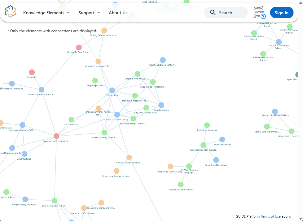
This vision for the Platform mirrors what AI and data science capabilities could and should be. For example, I-GUIDE’s activities around robust geospatial data science, including the new Data Ethics Toolkit and measures of uncertainty are becoming increasingly integrated into the Platform. Ultimately this will expand how FAIR data principles can actually be supported in practice. The linkages between computational notebooks, software code, datasets, and research publications, and open educational resources, known as “knowledge elements” on the Platform, can be visually depicted as components within a knowledge network, providing additional ways to discover and expand research collaboration.
Currently an annual initiative is underway that leverages the Platform for wider community benefit. Eleven teams are participating in a Spatial AI Challenge to generate novel solutions and insights for sustainability and resilience factors. The 2025-26 cohort includes problems around flooding, wildfire mapping, transportation and mobility access, and assessing disaster impacts. Devika Jain, of Harvard University’s Center for Geographic Analysis, describes her group’s experiences as a member of the 2024-25 cohort:
“We used the I-GUIDE platform through the Spatial AI Challenge 2024–25 to advance our Geography of Human Flourishing project, which develops 48 nuanced indicators of Human Flourishing by applying Large Language Models (LLMs) to over 3 Billion Geotweets. It provided more than 24,000 hours of computing support needed to scale our ambitious research, along with valuable technical and subject matter expertise. Finally, it enabled scalable and reproducible access to our large AI models and datasets for the broader spatial community. I-GUIDE exemplifies a future-ready platform for the next generation of GeoAI and spatial data science research.”
One exciting feature about the Platform is its Python-based Smart Search framework and the scalable workflows it enables. Regular advances in knowledge discovery and retrieval coming from the generative AI community are readily incorporated. For example, the Platform has recently integrated a vision model that supports cartographic map interpretation as well as explanation of notebook outputs and visualizations, allowing users to uncover and reveal latent relationships among seemingly unrelated knowledge elements. Another example is a Notebook extraction pipeline that enhances the discoverability and reusability of the functions, analytical logic, and workflows embedded within each Jupyter Notebook. Such powerful augmentation of knowledge elements advances the vision of integrating Smart Search and generative AI capabilities within the I-GUIDE Platform to support autonomous AI agents capable of performing analytical tasks over an ever-expanding knowledge base. These AI agents are being actively developed to optimize workflows ranging from geospatial data search, download, and processing, to machine learning model selection, construction, training and deployment. These agentic workflows promise to lower barriers and expand opportunities for geospatial data-intensive and convergence research.
Curious to see yourself how this will work? Create an account on the Platform, explore the Getting Started documentation, explore the content (and consider adding your own for the community). And let us know what you think! You can write to us at help@i-guide.io, and find here all the options for receiving our updates and announcements.